A Typological Description and Analysis of Archaic Monuments
See footnote for information on this section of the text.1
I. Residential Monuments
This division of archaeological sites includes all types of monuments that were designed and built for residential activities. Within this division are those monuments that were used for human habitational activities, whether of an economic, political, religious or domiciliary nature. In a land where much of the population is likely to have lived in tents and other temporary shelters from time immemorial, permanent habitation in well-built edifices must have largely been the domain of the higher strata of society. In this work, information on 162 residential sites is presented.
I.1) Residential Structures Occupying Summits
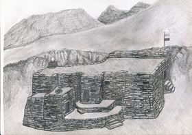
In this residential type are all habitational structures located on the summits and prominences of mountains, ridges, hills, and high rock formations. By the very nature of these geographic locations, such monuments have an inherent defensive aspect to a lesser or greater extent. Among this residential type are edifices that functioned as fortresses and citadels (habitations designed and built for military purposes), temples and hermitages (buildings with a religious or ceremonial function), palaces (social elite residential buildings), and breastworks (networks of ramparts or other types of defensive structures that were temporarily or permanently inhabited). It must be noted that, from a visual appraisal alone, the specific occupational functions of individual edifices or components thereof can only be inferred. In any event, these strongholds, temples, palaces, and hermitages appear to have been where the ruling and priestly classes exercised their social influence and political control over the agriculturalist and pastoralist sectors of society.
I.1a) All-stone corbelled buildings
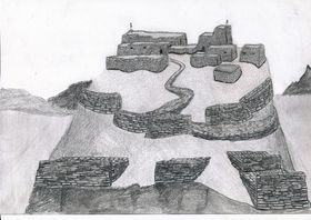
This building subtype represents one of the most prominent classes of residential structures found in Upper Tibet. In the parlance of the region, this style of architecture is often referred to as dokhang (all-stone habitation). This form of construction is characteristic of the archaic cultural milieu of the region, and is eminently well suited to the environmental exigencies of the harsh landscape. It is in Upper Tibet that all-stone corbelled buildings reached their fullest architectural expression in all of Central Asia. This building design is exceptionally rugged and structurally stable, and individual examples may, in some cases, have endured as habitations for centuries.
All-stone structures feature the use of corbels, stone members that were placed on the upper extent of walls as load bearing devices for the stone roof assembly. Corbels were simply rested on the tops of walls or were inserted into specially built wall sockets. Corbels act to support bridging stones and stone sheathing from which the roof was made. Bridging stones were laid diagonally or crosswise in one or more courses over the corbels in order to span the distance between opposite walls. In turn, large slabs of stones were placed upon the bridging stones to create a complete roof covering. The elementary corbelling technique employed in Upper Tibet for roofs was only suited for use over small interior spaces (typically 3 m² to 12 m²). Large edifices were created by juxtaposing multiple, structurally self-contained rooms or groups of rooms together to form a contiguous ground plan. In some places (such as sites A-10 and A-54) corbels with sockets were used to support the stone flooring of a second story in the same fashion as roofs were constructed.
All-stone corbelled edifices have many unique design traits. In general, they are massively built, a consequence of the great weight that the roofs bear on these structures. Walls are between 60 cm and 1.2 m in thickness, and of a slab or block random-rubble texture. Both dry-mortar and clay-mortar seams are represented in their construction. Roofs are, as a matter of course, flat and originally must have been layered in gravel and clay to weather-proof the buildings (little evidence of this more ephemeral aspect of construction has survived). As each room or group of rooms is an isolated unit structurally, the exterior walls of such structures have an irregular or even a meandering plan. Walls are of variable thickness, with various exterior indentations and interior recesses common. Both exterior and interior corners tend to have a rounded quality, as this facilitates the arrangement of corbels. Interior walls are punctuated with buttresses that function to support intervening series of corbels and roof appurtenances, especially in larger rooms. The floor-to-ceiling height of rooms in dokhang is usually relatively low (1.6 m to 2 m). Most buildings are windowless and even in certain structures where there are interior and exterior window openings, these are small in size.
Single buildings contain between two and one dozen rooms, which are normally arranged in rows or isolated aggregations. Rooms directly open onto one another or are connected through a small corridor or interclose. Various wings in a single building usually had separate exterior entrances, as large interconnecting halls and galleries are not possible in dokhang construction. Another defining feature of the all-stone corbelled edifices is the very small size of their doorways; these average only around 1.1 m in height. The lintels of the entranceways (and the few windows) are made from stone. The heavy windowless walls and low doorways of the rooms indicate that they must have been weatherproof and easy to heat. Collections of small rooms also indicate that a decentralized or compartmentalized domestic ecology was the norm. Individual cells must have been set aside for the various facets of everyday life such as sleeping, food preparation, storage of provisions, and religious observances. Rooms were only large enough for individuals or small family units. Cooking, meetings and ceremonial life inside the dokhang could only have revolved around small groupings of people.
Customarily, sundry dokhang on a summit were vertically interconnected to create a staggered array of structures. Naturally occurring rock outcrops and ledges were commonly used to help support corbelled buildings and to act as one or more walls of the structure (particularly in the rear). This form of construction is very favorable to incorporation into the adjoining terrain, as walls could be built to accommodate the twists and turns of rock faces. This high degree of integration with the parent formation is a distinguishing feature of dokhang design. Although corbelled edifices individually have low architectural elevations (there are no high ceilings in rooms, and parapet walls where they exist appear to have been minimal), the stacking of one on top of another has the effect of producing formidable complexes. It is not uncommon to find these clinging to the sheer walls of a summit for many vertical meters. In sites that appear to have functioned as hermitages, individual residences tend to be separated from one another rather than forming aggregated complexes. The use of prominent revetments, a common feature, significantly increased the elevation of exterior faces. Revetments function to give buildings a stable foundation and to even out the dips and rises on rocky summits. Rather infrequently, all-stone edifices were integrated with other building types at a single site. Occasionally, there is also evidence to suggest that the basement or lower story of a building was fashioned as a dokhang, while the superstructure was of an alternative style of construction (see site A-51).
The wide distribution of dokhang through most areas of Upper Tibet and their superb adaptive bearing indicates that they were a chief residential type for a long period of time in the region. Bronze Age occurrences of corbelled edifices in regions like the British Isles and Mediterranean may suggest that this form of architecture developed in Upper Tibet at a relatively early date. The lack of demonstrable monumental precedents in the archaeological record of Upper Tibet reinforces the impression that all-stone edifices have a very long legacy behind them. Chronometric data on the sites surveyed are now undergoing compilation; these results furnish the best archaeological evidence corroborating the archaic nature of Upper Tibet’s all-stone edifices.1
I.1b) Edifices built with timbers
This heterogeneous monument subtype includes all residential structures that were built with roofs containing timbers. Among the examples included in this inventory may be sites that were actually founded or redeveloped after the early historic period that could not be differentiated from older strongholds (because of the possession of similar morphological and cultural attributions). Further archaeological investigation will be required to clear up this typological ambiguity. Edifices constructed with wooden roofs located on summits generally have a good defensive posture. As with the all-stone corbelled structures, their domiciliary usage appears to have varied greatly. Citadels, fortified settlements, temples, and palaces are all probably represented among this class of habitation. These timbered edifices are of four major wall fabrics:
- Random-rubble and coursed rubble stone walls
- Adobe or unbaked mud block walls (sapak)
- Rammed-earth or shuttered walls (gyang)
- Walls of cut earthen slabs
i) Residential structures built with stone walls are commonly encountered throughout Upper Tibet. Where walls are left standing, this type of construction is readily identifiable: walls are straight and regular and can be of considerable length. As roofs were built with wooden timbers, the walls supporting them were not required to be as massive as structures with much heavier all-stone roofs. The regular buttressing and indentations of dokhang walls is also conspicuously absent. Moreover, high elevation profiles and large rooms and halls are found with much frequency, especially among Buddhist complexes. However, what appear to be archaic structures built in this manner share some of the customary features of dokhang design. These include edifices with smaller rooms, windowless walls, relatively low entranceways, adeptly constructed random-rubble slab walls, a high degree of topographical integration into the parent formation, the proliferation of small buildings staggered vertically across a summit, and series of small ramparts.
None of the stone wall buildings surveyed have their roofs intact but the general constructional pattern and the rare presence of timber fragments suggests that roofs were constructed much as they were in the Central Tibetan style of architecture. This entails the laying of timbers across the top of walls and covering them with wooden and/or stone interlinking materials. Once the roof was completed in this fashion, wattle, clay and possibly Tibetan cement (arka) must have been used to build successive enclosing layers. Unlike the traditional architectural landscape of Central Tibet and Eastern Tibet, there is no evidence of towers having been erected in Upper Tibet, stone buildings of more than two stories being rare in the region.
A site attributed to the ancient Mön in the oral traditions of Upper Tibet Kapren Gyanggok (A-33) was in use as late as the 13th century CE. Chronometric data obtained from Kapren Gyanggok reinforces the view that monuments attributed to the Mön must be understood in a broad historical and cultural framework.
ii) Residential structures built with adobe blocks are commonly encountered in Gugé, that large Transhimalayan badlands region in the Sutlej (Langchen Tsangpo) drainage area of deep gorges and highly eroded earthen formations. While mud-brick walls are common in Buddhist era buildings (such as monasteries and retreats) in the Jangtang, there is scant evidence that such structures were established in pre-Buddhist times. One exception may be a complex of buildings at Drakgam Dzong (B-40). It was founded on a slope overlooking the Mukyu Tsangpo basin, a rich pastureland.
Adobe block edifices were founded in great numbers in Gugé in the Buddhist era. According to the local oral tradition, they were established in the prehistoric epoch and had been the handiwork of that elusive tribe the Mön or Kel Mön/Kel Mön.2 From an environmental perspective, this claim of antiquity for elementary earthen structures is plausible, for building stones are in short supply in many corners of Gugé, and lithic materials appropriate for corbelling and bridging only very seldom occur. The antiquity of adobe block constructions is also supported by recently compiled chronometric data from the Rula Khar site (A-141) (see below). Systematic survey of sites in Gugé, to which oral tradition assigns an archaic identity, has brought to light physical evidence, which tentatively permits adobe structures to be chronologically differentiated from one another. One distinguishing criterion employed in trying to determine what may be examples of archaic adobe edifices is based on an analysis of building design. Sites such as Hala Khar (West) (A-58) strongly contrasts with known Buddhist architecture of the region. Its highly exposed and isolated aspect, unusual ground plan and extremely deteriorated condition are circumstantial evidence for the inclusion of Hala Khar (West) in the category of archaic monuments. This single 32 m long contiguous complex consists of four rows of tiny rooms that run parallel to the axis of the summit at different levels. No Buddhist monuments or emblems are found at Hala Khar (West) and no Buddhist religious lore is attached to the site.
The survey of citadels and other summit residential structures attributed to the ancient Mön in the localized traditions of Gugé demonstrates that most of the facilities exhibiting mud brick wall construction are in fact primarily built of stone. At most so-called Mön sites adobe walls were used for relatively minor constructions and for upper wall courses. What adobe walls do exist are as a rule much more highly eroded than Buddhist constructions. At none of theMön castles (möngyi khar) are there large, high-walled buildings (lhakhang, dükhang, etc.) like those found at virtually every Buddhist monastery in Gugé. Moreover, sites attributed to the archaic period of construction are often associated with troglodytic communities with few or no signs of Buddhist occupation. A foundation or refurbishment date of circa 565 to 705 CE is indicated for the adobe block northwest edifice of Rula Khar (A-141). The relative position of the radiocarbon assayed sample in the building confirms that adobe block constructions were indeed part of the archaic architectural canon of Gugé.
iii) Rammed-earth residential structures that local oral tradition places in the archaic period are limited in geographic range to lower elevation western Ngari Korsum and in particular, to Gugé. A single wall of this construction type attributed in the oral tradition to the Zhangzhung kingdom is found at the high point of the Takla Khar fortress (A-81) in Purang. In Gugé, summit strongholds such as Jangtang Khar (A-116) and Sharlang Khar (A-118), two castles that in the local oral traditions are assigned to the Kel Mön, have rammed-earth structural remnants. Walls of this type, nevertheless, are found at only a minority of strongholds attributed to the ancient Mön in Gugé. The technological origin and chronology of rammed-earth walls, built by packing wet earth and clay with a stone matrix between large wooden shutters, is not at all certain. It may be that rammed-earth structures are wrongly attributed in legend to the archaic period or that they were founded at sites with structural remains from earlier periods of occupation.
iv) At just a few fortified sites in Gugé another type of wall was formed from naturally occurring compressed slabs of earth, which were cut from the native formations. Structures built with this type of wall dominate at Cholo Puk (A-113) and Rakkhashak Möngyi Khar (A-115), strongholds attributed by local residents to the Mön. At Cholo Puk, a sequence of chambers were cut out of the long flat summit, and the slabs resulting from the excavation used to build walls above the top of the excavated chambers. Parapet walls were also built around the edges of the summit using the same natural earthen slabs. The absence of monuments indicative of Buddhist occupation at these sites, as well as their semi-subterranean aspect, encourages the view that earth slab fortifications do indeed date to the era of archaic residential structures.
I.1c) Solitary rampart networks
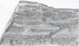
Some strongholds in Upper Tibet are exclusively composed of networks of defensive walls traversing summits and adjoining slopes. At sites such as Namdzong (A-48) and Takzig Nordzong (A-50) there appear to be few, if any, residential buildings, but rather a series of ramparts fortifying a strategic mount or rock formation (those in proximity to a high quality pasture or important pass). These random-rubble dry-mortar breastworks consist of long walls that wind across slopes vulnerable to attack. Typically, the walls are 1 m to 2 m high on the downhill slope, and slightly elevated or flush with the uphill side of a slope. These defensive structures are normally around 1 m to 2 m in width, and between 2 m and over 100 m in length. Parapet walls or ledges were probably built on the outward projecting edge of the ramparts but much of the structural evidence for these features has disappeared down the slopes with time. A chief characteristic of rampart network design and deployment is that they appear in multiples, each wall running in a transverse direction at different elevations and somewhat parallel to one another. An approachable slope may have upwards of eight successive ramparts, one above the other, guarding the higher and more vital reaches of a site. In addition to being aligned in parallel, defensive walls join one another or branch out in different directions across ribs of rock and broad acclivities. Some of the wider, more level and sheltered breastworks appear to have functioned as platforms for camps and the garrisoning of fighters. The intricate arrangement of breastworks as the exclusive or dominant architectural component of a fortified site bespeaks a special form of defensive posturing by which entire rock formations functioned as strongholds.
While some sites seem to have been comprised entirely of breastworks, most of the archaic fortifications of Upper Tibet heavily relied on them for defense. At many citadels, defensive walls form an integral part of the complex. These are of three major types: 1) those staggered below residential structures that are erected on a summit; 2) those that encircle the main nucleus of habitation (circumvallations); and 3) those that connect various residential structures (curtain-walls).
I.2) Residential Structures in Other Locations
This type of residential site includes all monuments situated in any geographic locality other than those set on top of summits. Such habitations are found on broad slopes (those with higher ground in the immediate area), valley bottoms, ravines, gorges, benches, esplanades, headlands, and at the foot of or in escarpments and outcrops. However, such sites are seldom found in the midst of large exposed plains. The same kind of constructional and design elements exhibited by the summit residences are part of this category of archaic sites. The majority of them appear to have been habitations for religious and other high social status forms of residency. We might expect that, when most of the population of the Jangtang was housed in black yak hair tents (dranak) and other types of temporary shelters, the occupation of highly weatherproof permanent habitations was a mark of social distinction and achievement. This, indeed, was the state of affairs in the pre-modern Jangtang. Cave residences are found throughout Upper Tibet, but in numbers that would not have permitted more than a small fraction of the total population to avail themselves of such facilities in any given period (with the notable exception of Gugé with its many thousands of caves).
I.2a) All-stone corbelled buildings
These edifices are of the same design and construction as those perched on summits, the main difference between them being situational in nature. As such, all-stone corbelled buildings or dokhang located away from high ground lack a strong defensive aspect. Functional differences in the kinds of occupancy may be implied by these locational contrasts. All-stone edifices removed from summits tend to be individual dwellings separated from one another by meters or tens of meters of distance. This contrasts with the clustered plan of many summit sites.
There are differences in design that arose in accordance with varying physical settings. Dokhang in lower, more open areas often have walled courtyards on their forward (usually east or south) side. These domestic spaces, enclosed by random-rubble dry-mortar walls, must have been used for chores, social functions and other activities appropriate to the outdoor environment. Another difference is that these less defensible dokhang frequently have a semi-subterranean aspect. Typically, the rear or uphill slope walls were set deeply into the ground, sometimes so much so that the roof was nearly flush with the slope. In areas where there was an adjacent cliff or rock face, one or more walls of the structure were set partially or entirely below it. Clearly, this saved on the amount of building materials but there are likely abstract cultural factors at play as well. Rear walls of the all-stone corbelled buildings frequently have niches and recesses built into them, adding to the underworld atmosphere of the structures. These subterranean compartments may have had a ritual function such as that connected to the propitiation of chthonic deities.
I.2b) Other free-standing building types
This subtype includes all habitations built with wooden roofs not located on summits. Many of these structures appear to have supported timber roofs. Potentially, sites that had semi-permanent roofing materials such as yak hair cloth or hardened yak hide are also among this category of edifices. The constructional characteristics of sites like Lung Ngak (B-80) and Dechö Kelmön Yül (B-81) are difficult to judge. Their wall design, building dimensions and alignments appear to have supported less substantial semi-permanent roofing materials. A building with a wooden roof situated in the middle of open ground that can be attributed to an early period is Bumo Lhakhang (B-87), a highly unusual adobe block edifice. Among the sites of an indeterminate subtype are those that appear to be the vestiges of sizable villages, which were seated on wide benches or gentle slopes. These are usually so deteriorated that only zones of rocky depressions and mounds exist where there were ostensibly once domiciles (see B-71, B-85).
I.2c) Buildings integrating caves and escarpments in their construction
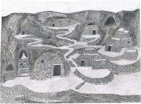
This building subtype is also defined according to geographic placement. It includes all residential structures that were set in or around caves, rock overhangs and fissures. Caves, especially when accompanied by freestanding residential structures, provided one of the most secure and hospitable living environments in the archaic cultural horizon, as they have in more recent times. Most Lamaist era cave habitations were the domain of religious practitioners, but in archaic times it appears likely that a wider spectrum of society was housed in this fashion. Local legends indicate that such sites constituted the original nexus of settlement in numerous locales. This is borne out by the existence of high quality springs at some sites, in stark contrast to the surrounding, often waterless plains. The formative historical nature of cave settlement appears to be particularly the case in the Transhimalayan Gugé region.
In the Jangtang most caves are ensconced in limestone formations. The most common architectural feature in this category of construction is the façade wall, a barrier that served as the front for caves. Stone and mud bays, altars, shelving and platforms are sometimes found inside the caves. In Gugé, where most of the caves were hewn from earth and gravel formations, arched recesses and niches are characteristic internal features. Multi-room and even multi-story edifices were also established within the embrace of caves and rock shelters. These structures possessed both all-stone corbelled roofs (see B-107) and roofs with wooden beams and wattle (see B-110). In addition to dwellings, sanctuaries and temples were sometimes located in larger caverns (see B-108, B-119). These sites have internal structural features such as ceremonial platforms, partition walls, shrines, and even pictographs (see B-118, B-119).
II. Ceremonial Monuments
This division of monuments includes all types of archaic archaeological sites that had a non-habitational ritual or symbolic function. Included within this division are various types of pillars, some of which are associated with superficial constructions of different kinds (most are funerary superstructures). Other pillar complexes boast above-ground tombs and reliquaries. A variety of smaller shrines and tabernacles are also part of the ceremonial division of Upper Tibetan monuments.
II.1) Stelae and accompanying structures
One of the most captivating types of archaic archaeological site in Upper Tibet consists of stelae, pillars or menhirs either in a solitary aspect or in groups forming special kinds of arrays. In this work, descriptions of 110 sites featuring pillars are presented. The Tibetan generic term doring is applied to pillars of all species in Upper Tibet. These standing stones vary greatly in size (15 cm to 2.4 m in height) number and layout, which is indicative of a fairly broad variety of ritual applications and cultural contexts. As with the dokhang residential monument, pillars without inscriptions reached their highest level of development on the plateau in Upper Tibet. Pillars exhibiting different morphological characteristics were erected hewn or unhewn, and were made from a diverse assortment of rocks (including igneous, volcanic, metamorphic, and sedimentary). Pillars, whatever their function, were planted firmly in the ground by first excavating a hole to accommodate 30% to 50% of the total length of the stone. Over the centuries, through the agency of gravity and geomorphologic change, it is common for pillars to have collapsed or to tilt in a downhill direction. Gently and even radically inclined pillars are encountered at many sites. Pillars in the Upper Tibetan archaic archaeological context appear to have functioned as political monuments for clans and chieftains, cultic sites for the worship of deities, good fortune enhancement and harm reduction instruments, and as memorials and ritual dispensation sites marking cemeteries.
II.1a) Isolated pillars
Pillars that stand alone or in groups (two to twenty in number) in isolation from other structures are commonly distributed in the Jangtang west of 90° 45΄ E. longitude. Lone pillars are also found in a few locations in Gugé and Purang. The function, significance and chronology of pillars that stand alone, without the benefit of other structures that can serve as interpretive benchmarks, are very difficult to assess. It appears that some pillars, grouped in rows, heralded the existence of cemeteries. Lines of pillars that probably mark grave sites are found in places like Gyaplung Doring (C-13) Doring Gyaplung (C-23) and Dzatsok Doring (C-28). There are probably other examples among the pillar sites recorded where physical evidence of the tombs has been effaced from view. Individual pillars are also known from certain grave sites (see D-72). Solitary pillars, especially those in Gugé, appear to have had a cult function pertaining to the worship of local deities (see C-14, C-169, etc.). Some of these stelae are still used in the placation of indigenous spirits at annual community rites (such as the lhasöl, held during sowing and harvesting). Other solitary pillars could have been erected as territorial markers; such is the local oral tradition surrounding Chunkhor Doring (C-25). Finally, it is also plausible that some of what now appear to be isolated groups of stelae were in fact erected inside quadrate stone enclosures, the signs of which have been obliterated.
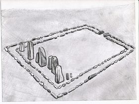
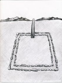
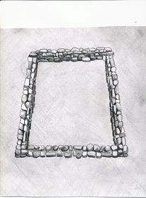
II.1b) Pillars erected within quadrate enclosures
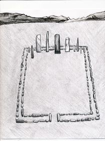
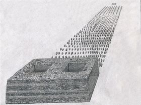
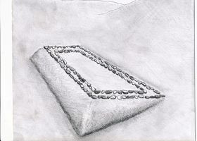
Pillars erected within square or rectangular walled enclosures represent one of the most distinctive types of archaic ceremonial monuments in Upper Tibet. Due to their unique morphological characteristics and territorial specificity, they serve to delineate the paleocultural domain of the region. Pillars erected within a quadrate enclosure were most often built in open areas such as plains, large benches or wide slopes endowed with long vistas to the east. They are customarily founded on well-drained level or very slightly sloping gravelly or sandy terrain, with a ridge or hill serving as a western backdrop. Some sites overlook lakes, rivers and marshes, while others are found in waterless areas. One or more pillars are invariably set on the west side of a stone enclosure, in close proximity to the inside edges of the bordering walls. In most cases, the enclosures are generally aligned in the cardinal directions and less frequently, in the intermediate directions. One to more than a dozen pillars was planted inside a single enclosure. Pillars vary significantly in shape and size. They can be tabular, four-sided, three-sided, or irregularly-shaped, and range in height from 20 cm to 2.4 m. Tabular pillars usually have their two broad sides oriented north-south. They have both flattened and pointed tops. Some pillars were carefully cut into regular shapes, while at most sites, raw stones were used for installation. Pillars erected inside a quadrate enclosure were constructed from a wide variety of locally occurring lithic materials, and it is not uncommon for more than one type of rock to have been used in construction, creating structural elements of contrasting colors and textures.
At some locations, one or more walls of the enclosures are raised above the surrounding terrain in order to maintain a level interior. Rectangular enclosures regularly have longer dimensions east to west. An exception is encountered in certain rectangular enclosures in far western Tibet, which have longer north to south dimensions. This constitutes a regional design variation with no other significant morphological differences observed. The enclosures vary in size between 3 m by 3 m and 14 m by 22 m. The walls forming the perimeter of the enclosure normally contain parallel courses of stones, and range between 40 cm and 80 cm in thickness. Most enclosures are constructed of unhewn upright stone slabs or blocks (10 cm to 80 cm in length), which are embedded in the ground. These stones are level with the ground surface or are elevated above it to a height of 10 cm to 40 cm. However, some enclosure walls are composed of two to four vertical layers of blocks and may be as much as 50 cm in height. It is not uncommon to find both superficial and built-up wall sections in a single enclosure. In some examples of the enclosure, there is an opening in the middle of the east wall, which appears to have functioned as an aperture of ritual importance.
Most commonly, there is just one walled pillar monument per site but at some places there are two, which are spaced 10 m to 1 km apart. In more recent times, a significant minority of the pillar sites was used in apotropaic and fortune-bestowing rituals associated with the indigenous pantheon. Pillars erected inside quadrate enclosures are frequently found in proximity to other funerary structures such as slab wall arrays, burial tumuli and other types of tomb and funerary ritual superstructures. Funerary structures are discernable at more than one third the total number of walled pillar sites surveyed. It seems likely that most of these pillar monuments originally accompanied some form of burial, the signs of which are not necessarily visible on the ground surface. It does not appear, however, that the pillars were raised directly on top of tombs.
Pillars erected within quadrate stone enclosures appear to have functioned as memorials or commemorative monuments for the deceased, who were buried in outlying tombs. Special rites may have taken place inside the enclosures such as the depositing of offerings and the lighting of sacrificial fires. Archaeological investigations show that analogous enclosures of the Scytho-Siberians and Turks were used for such purposes. The erection of pillars may have acted as a symbol of temporal power, linking the tribal leadership with their ancestral rulers and deities.1 A localized clan or cultic function connected to the levers of social and political power is suggested by the solid distribution of the monument throughout its territorial scope.2 Dunhuang and Bön funerary accounts suggest that the erection of pillars occurred in rites designed to lure the souls of the deceased to the center of ritual operations, so that they could be sent on to the ancestral afterlife. The funerary pillars of the Bön literary tradition are known as ‘receptacles of the soul’ (layi ten).
Pillars erected within enclosures or in isolated rows occur in the north Inner Asian funerary archaeological record as well. The morphological, functional and geographic aspects of the late Bronze Age and Iron Age pillar monuments of the steppes indicate that they have significant cultural and ecological affinities to the Upper Tibetan pillars erected in quadrate enclosures. These interrelationships are examined in Zhang Zhung: Foundations of Civilization in Tibet. Linkages as cognate ideational, technological and environmental innovations suggest the kind of time frame in which the Upper Tibetan pillar monuments originated and developed. Nevertheless, the doring of Upper Tibet represent unique conceptions of design, spatial ordering and ritual practice, which are indicative of a cultural entity distinct from its northern neighbors. Cross-cultural archaeological comparisons with the Scytho-Siberians encourage the view that the walled pillars sprang up in Upper Tibet as early as the beginning of the first millennium BCE. Unlike the tumultuous steppes with their great clashes of peoples and the attendant disintegration of cultures, the pillars of Upper Tibet seem to have survived as a relict cultural form perhaps through the imperial period. The geographic isolation of Upper Tibet from the epochal human movements of north Inner Asia, and what appear to have been its relatively stable economic and cultural systems, argue in favor of the long-term persistence of the monument.

Pillars erected inside quadrate enclosures are well distributed throughout Upper Tibet, west of 89º 26΄ E. longitude and south of 33º 30΄ N. latitude, with the exception of Transhimalayan Gugé. The geographic bounds of this pillar subtype correspond to what we might call the ‘core area’ of Upper Tibetan archaic cultural entity. The absence of these emblematic monumental features in the far eastern Jangtang (or in any other region of the Tibetan Plateau) indicates that these regions had different cultural and/or ethnical compositions. As the pillars erected in quadrate enclosures possess definitive design and constructional features, setting them apart from the archaeological monuments of adjoining regions, they are admirably suited to serve as territorial markers delineating the heart of the Upper Tibet paleocultural zone. It would appear, based on the monument’s areal distribution, that this unique Upper Tibetan ecological and cultural domain is tantamount to the prehistoric and early historic Zhang Zhung cultural sphere of the Tibetan textual tradition.3
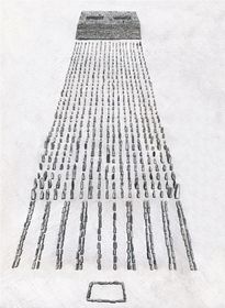
II.1c) Quadrate arrays of pillars with appended edifices

Vertically set stones, erected in rows aligned in the cardinal directions to produce large formations of pillars, share the same geographic scope as the pillars erected inside enclosures. These pillar arrays were also usually constructed on level or slightly inclined ground with deep vistas to the east. They are found on the edges of plains or on broad esplanades, often bounded in the west by a ridge or mountain slope. In most instances, fields of standing stones appear to have been established in areas remote from human settlement, for many of the sites are devoid of permanent sources of potable water. In a single complex, there were between several hundred and 3000 pillars set into the ground in more or less evenly distributed rows. Considerable attention was devoted to insuring the orientation of the pillars and the integrity of the grid pattern.
The concourses of stelae vary greatly in size, and cover between 30 m² and 4000 m². The stelae range in height from 15 cm to 1.4 m, with an average protrusion above the ground of around 40 cm. These pillars were made from either natural pieces of stone or perhaps from rocks that were roughly cut into shape. The smaller specimens tend to be pointed. Many of the larger stelae are tabular in form and have their broad sides aligned in a north-south direction. They are made from a variety of stones, depending on the geological makeup of the locale. The rows of standing stones are positioned 40 cm to 1.2 m from each other, as are the individual stones that make up a row. At some sites, slabs of stone (10 cm to 1.2 m in length) were embedded in the ground edgewise, often in parallel courses, around the array of standing stones. The same slab walls are sometime used to subdivide the concourse of pillars into smaller units. These 20 cm to 40 cm thick slab walls are flush with the surface or protrude above it to a maximum height of 20 cm. There are also numerous instances of double-course slab walls, extending 3 m to 30 m east of the pillar arrays, to create an extensive grid of parallel structures which are also aligned in the cardinal directions.
One to six meters west of an array of pillars is what appears to have been a mortuary temple cum tomb edifice. The lines of pillars seem to have almost reached the tomb but, at many sites, proximate rows have been uprooted. Like the pillars themselves, these masonry structures are usually aligned in the cardinal directions. They vary greatly in size and complexity, ranging between 3 m to 65 m in length. The tallest surviving temple-tombs are 4.3 m (Yül Khambu, C-143) and 3.5 m (Shasha Pelkhang, C-145) in height, but originally they may have been substantially taller. Although none of the top-most part of these structures has endured, they were almost certainly built with flat roofs, probably of an all-stone corbelled composition. In the larger edifices, the windowless walls are up to 2.5 m in thickness, creating relatively small, hermetically sealed, interior spaces. This clearly indicates that these structures were not built for habitation. Where significant elevations have survived, it can be discerned that most were four-sided structures, the larger of which were divided into two to five or more compartments. It appears that these robustly built internal spaces were burial or reliquary chambers. Taller walls of the temple-tombs slightly taper inwards in the Tibetan ‘fortress’ style of construction, a design feature not well articulated in other Upper Tibet archaic monument types. Walls were constructed of coursed-rubble of variable-sized stone blocks and slabs whose exterior faces were hewn smooth. Masonry courses were laid flat, as well as in a distinctive ‘herringbone’ pattern, whereby two intervening courses were set diagonally into the wall. To reinforce larger walls, courses of thin bond stones were also employed at strategic levels. The interior walls appear to have been built of finer masonry than the exterior walls. Small quartz crystals and pieces of red sandstone are found scattered at some sites; these may have been employed as decorative or ritual elements.
In the local oral tradition, the monolithic arrays and accompanying mausolean tombs are often accorded a funerary function associated with the ancient Mön tribe. Local reports hold that human skeletal remains were discovered at certain sites, indicating that they did indeed function as necropoli. Other types of tomb superstructures and pillars are quite often found in close proximity to the pillar complexes, corroborating this view. It would appear that the edifices appended to the pillars functioned as tombs and as temples where mortuary and perhaps commemorative rites were conducted for the interred. The ritual function of the fields of standing stones is a mystery. There is some speculation among local residents that each pillar represented a single individual, as in the constituent members of an ancient army. Some drokpa believe that under each pillar are the remains of an individual. Such an impression emphasizes the corporate or community-based aspects of the monument as important centers of ritual dispensation and social interaction. The pillars may have ritually functioned to capture the souls of the deceased before their send-off to the afterlife. This old Tibetan funerary culture motif would seem particularly relevant if the quadrate arrays of pillars with appended edifices were founded to honor those fallen in battle. According to the Bön archaic funerary texts, those who die from violent causes (driwo) require elaborate apotropaic and fortune-bestowing rites to be carried out in order to commend the soul to the ancestral paradise. Markers (to), probably represented by stone cairns or pillars in some cases, are recorded in these funerary texts as being essential in pressing down (nönpa) potentially harmful chthonic spirits such as the lu and si. This kind of rite was carried out by priests known as durshen and dri bönpo.
The effort made to align the edifices and networks of pillars in the cardinal or intermediate directions is in itself highly significant. I am inclined to see this orientation as reflecting important religious preoccupations pertaining to the celestial sphere. Solar, lunar and/or sidereal alignments and calendrical parameters may have been incumbent in the spatial bearing of the structures. According to Bön ritual literature, many of the deities of Zhang Zhung were associated with celestial and meteorological phenomena, and similar religious traditions may also be implicit in the careful alignment of the pillars and edifices.
The relative scarcity of arrays of pillars appended to temple-tombs (the obliteration of specimens notwithstanding) and the highly elaborate nature of their construction allude to an exclusive social sphere. It seems most likely that these necropoli are where the elite of society (the regional priestly and/or ruling classes) carried out ritual functions for those of similar rank, and where they were ultimately inhumed. Such cultural activities are likely to have been conducted with the large-scale cooperation and participation of local communities. The existence of great complexes scattered across Upper Tibet from 89° 26΄ E. longitude west to the southeastern extent of Gugé (80° 47΄) may also indicate that there were multiple geographic centers of political power. A dispersed dominion is supported by the legends of the Zhang Zhung kings occupying various residences across much of Upper Tibet.4 Such archaeological and textual evidence buttresses the widely circulating hypothesis that Zhang Zhung was a tribal confederacy or decentralized state, where political power was largely in the hands of the constituent regions and/or clan factions.
The extensive use of pillars in Inner Asia is first attested in south Siberian Okunev burial sites (middle of second millennium BCE). Standing stones associated with burial sites are also prevalent at pre-Scythian (1200 BCE to 800 BCE) and Scytho-Siberian sites (800 to 300 BCE) in north Inner Asia. These pillars were erected in close proximity to funerary ritual enclosures, burial mounds and other types of mortuary structures. At southern Siberian Tashtyk sites (first to sixth century CE) one or even several rows of pillars with broad sides directed north and south are a common funerary architectural feature. Prolific use of standing stones is found at early Turkic burial sites (sixth to eighth century CE) of Mongolia, Tuva, the Altai, Kirgizia, Kazakistan and Xinjiang. These so-called bulbul stones can number up to 157 in a single row and are usually planted on the east side of slab wall enclosures (used for ritual or cremation purposes at early Turk burial grounds). The bulbul stones are 10 cm to 70 cm in height and spaced 50 cm to 5 m apart.5 As the pillar arrays of Upper Tibet share general technological, morphological and ritual traits with those found in the steppes, it suggests that certain religious conceptions pertaining to death diffused between the regions as part of a pan-cultural heritage.6 My findings indicate that Bronze Age ethnical commonalities, as well as the widespread development of nomadic pastoralism and the riding horse in the first millennium BCE, are likely to account for the fusion of certain abstract cultural elements in the steppes and Upper Tibet.
Clearly, however, the pillar arrays of Upper Tibet represent a unique form of funerary monument that developed and flourished only in this region. Nowhere else in Inner Asia did such large numbers of orderly arranged stelae arise at a single site. Moreover, the above-ground massively built mortuary temple-tombs of the Upper Tibetan context represent a remarkable cultural achievement, reflecting a good deal of indigenous technological and cultural sophistication. Foot bones extracted from a grave cleaved in two by a seasonal torrent at Khangmar Dzashak (C-160) have yielded a conventional radiocarbon age of 740 BCE +/- 40 years. This chronometric evidence indicates that such sites were established as funerary complexes by the first third of the first millennium BCE. The incorporation of the dated tomb between two pillar complexes at Khangmar Dzashak encourages us to view the stelae and appended temple-tombs as an integral part of the same spectrum of funerary traditions. As for the demise of this monument type: it seems unlikely that after Pugyel Tibet’s annexation of Zhang Zhung in the seventh century CE, such large displays of indigenous power and prestige would have been tolerated or even economically feasible. In any event, with the coming of Buddhist domination at the turn of the second millennium CE, the use of the arrays of pillars and temple-tombs must have been completely discontinued.
II.1d) Domestic Pillars
In 1998, a pillar was found erected in a still standing all-stone habitation at Dodrilbu (B-13). This 65 cm high pillar is found fixed in the small western-most room of this dokhang, which has much of its roof still intact.7 With the discovery of a second pillar in the poorly preserved remains of residential structure RS4 at Dingdum (D-64) by Mark Aldenderfer in 2001, a new class of Upper Tibetan pillar was positively documented.8 The analogous ground plan and relative geographic orientation of the RS4 and Dodrilbu structures indicate that the domestic pillars belong to the same Upper Tibetan cultural horizon. Aldenderfer’s dating of collateral organic remains at Dingdum to circa 550 BCE to 100 BCE, point to the erection of pillars inside habitations as having an Iron Age context. The habitations in which they were discovered are the largest in their respective residential sites, seemingly reflecting the high social status of the occupants. Isolated pillars may have been raised as part of local cults connected to the worship of territorial and clan deities.
II.2) Superficial structures
Superficial structures mostly consisting of stone enclosures, many of which appear to be the superstructures of tombs or funerary ritual venues, are found all over Upper Tibet. In this work 92 such sites are detailed. Without the benefit of excavation, the analysis of subsurface grave architecture and the study of grave goods, the typological classification proposed here must be seen as provisional. It is based on a visual appraisal of the morphology, orientation and constructional qualities of the various kinds of superficial structures, and makes no provision for chronological development or cultural affiliation. Superficial structures are found in large numbers throughout Upper Tibet, demonstrating that burial was once a dominant form of corpse disposal in the region. The archaeological evidence shows that the culture of burial spread widely and took a number of distinctive forms in the region. Very significant chronological, social, economic and even cultural variability is likely reflected in the diverse types of tombs found in Upper Tibet. It has not yet been determined which funerary superficial structures overlie tombs and which were only used in mortuary rites.
Superficial structures are frequently attributed in the oral tradition to the Mön in all areas east of the 89th meridian. They are commonly labeled möndur (Mön tombs), mönpé durkhung (tombs of the Mön), möndo (Mön stones), mönra (Mön enclosures), and mönkhang (Mön houses). In the eastern Jangtang, the Mön do not figure as a legendary motif; rather, large tomb complexes are often fancied to be the remains of monasteries that were destroyed by Mongol groups such as the 18th century CE Jungar.
II.2a) Single-course quadrate, ovoid and irregularly shaped structures (slab wall and flush-block constructions)
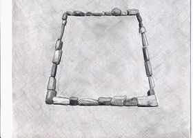
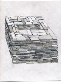
In regions of the Jangtang, west of the 89th meridian, stone enclosures, consisting of a single line of stones embedded in the ground, occur with much frequency. Among these diverse constructions are walls forming perimeters as well as single line stone walls subdividing enclosures into smaller units. These walls are built from naturally occurring chunks of stone, hewn stone blocks, cobbles, and slabs of stone set in the ground edgewise. The most eye-catching among the enclosures are those formed from slabs of stone that project prominently from the surface. A large range of locally available lithic materials were used in construction. It is not unusual for a single enclosure to have been built with more than one type of rock, such as limestone and sandstone together. These fencing stones vary from under 10 cm to over 1m in length. The individual stones of the walls are level with the adjoining terrain or project 10 cm to 60 cm above it. The enclosures vary greatly in shape and include ovoid, sub-rectangular, rectangular, square and irregular forms. Individual structures are between 2 m and over 25 m in length. The sheer differences in scale and the resources needed to build these structures may suggest significant socioeconomic variability. Many of the superstructures are flush with the surrounding ground but others are significantly elevated above it to a height of 1 m or more. There is a continuous elevational progression between the enclosures and burial mounds (bangso). Inside some enclosures, a small ring or mound of stones seems to mark the actual location of a burial chamber.
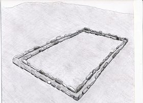
II.2b) Double-course quadrate, ovoid and irregularly shaped structures (slab wall and flush-block constructions)
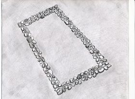
This monument subtype shares the same morphological, constructional and dimensional traits of the single-course walled enclosures, save that the perimeter walls are made with two stone courses running parallel to one another. The walls thus created are between 30 cm and 1.2 m in width. As these walls are inherently more substantial and better developed than single lines of stones, there are many more design variations among them. Most perimeter walls consist of a single layer of prone or upright stones embedded in the ground. In other examples, courses of blocks or slabs were laid flat in successive vertical courses (consisting of two to five layers of stones). These enclosures can quite closely resemble the footings of residential structures (see D-115). In other enclosures, three or more rows of blocks or upright slabs were arrayed in lateral rows to form walls (see D-45). At still other sites, row after row of small stones was stuck in the ground to blanket much of the interior of an enclosure (see D-107). The largest complexes of enclosures feature neatly built double-course walls constructed with cobbles, which sometimes stick prominently out of the ground. Extending over a transection of more than 1 km and numbering in the dozens, these complexes of far western Tibet may be associated with royal burials (see D-41, C-121).
Superstructures with parallel courses of slabs stuck in the ground edgewise constitute one of the most common monumental forms in Upper Tibet. They occur with many constructional variations and in many different sizes. Likewise, in Mongolia and Transbaikalia, the slab graves of the Slab Grave culture (circa 16th to 4th century BCE) represent one of the most widely distributed types of archaeological monuments. While cultural exchanges between the steppes and the Tibetan Plateau are clearly indicated, the distinctive morphological characteristics of the slab graves of Upper Tibet demonstrate that they belong to a unique paleocultural tradition. Rather than a singular class of monuments belonging to one group of people, the respective slab grave builders borrowed upon similar technical knowledge applied to the same purpose in environments largely suited to the herding of livestock. The bones of caprids, cattle and horses are found in the ritual slab enclosures of the steppes. Likewise, drokpa report finding the bones of these zoological genera in the single-course and double-course enclosures of Upper Tibet. Copper alloy artifacts of the Scytho-Siberian type have been discovered in the slab graves of the steppes. Those steppic grave goods compare closely with Tibetan copper alloy objects known as tokchak, the most prominent of which are copper alloy buttons, round mirrors with attachment loops and trihedral arrowheads.
|
|
II.2c) Heaped-stone wall enclosures
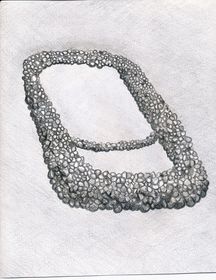
Enclosures created by incoherent or nondescript heaps of stones have the same geographic ambit as the single-course and double-course walled enclosures. It would appear that they were originally comprised of stones piled together to form sub-rectangular, oval and irregularly-shaped enclosures with open interiors. In some enclosures, stones are still heaped to a height of 1 m or more but most are considerably more leveled. The demarcation between the double-course and heaped-stone wall enclosures is somewhat ambiguous, for these forms of funerary construction have many morphological permutations, which are difficult to categorize in one subtype or the other. In the largest single heaped-stone wall enclosure of the Mönra Yarké site, which is known as Dzongchen (Great Fortress) (D-24), excavations carried out to retrieve stones for house and corral construction have revealed chambers constructed with large slabs of stone.1 Radiocarbon analysis of human bone samples taken from these chambers have yielded calibrated dates of circa 710 to 790 CE (leg bone fragment), and circa 610-690 CE (tibial plateau). These measured radiocarbon ages correspond with Tibet’s imperial period (629-846 CE). This demonstrates that the largest burial monument at Mönra Yarké was used to inter human remains during the period of Tibet’s greatest territorial and political expansion.
II.2d) Rectangular mounds (bangso)
|
|
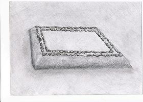
Burial mounds are found throughout Upper Tibet but do not appear to be as common as in other regions of the plateau. These square or rectangular tumuli are elevated on all sides and have inwardly tapering walls. The mounds invariably have flat tops, but the tops now undulate or are concave through the agency of centuries of erosion. I suspect that these mounds contain stone chambers used for interment and mortuary rites, as Tibetan literary accounts indicate. Inner stone chambers may be surrounded by earthen and rubble mantles, which were encased by stabilizing external stone walls crowned with decorative elements. As in Central Tibet, bangso are likely to have been constructed in the northwestern uplands at least until the collapse of the Tibetan empire in the mid 9th century CE. The largest bangso are located in Damzhung (see D-99, D-100), a region adjacent to Central Tibet. The large rectangular mounds (maximum size: 34 m by 32 m by 7 m) of Damzhung have been heavily plundered and are still in the process of being despoiled for valuables. Large quadrate funerary mounds are also found in the eastern Jangtang (see D-76), western Jangtang (see D-40, D-119, etc.) and at the southeastern margin of Gugé (see C-121).
II.2e) Terraced constructions
The most common funerary monument in the eastern Jangtang (east of the 89th meridian) consists of quadrate funerary structures built into the sides of slopes. Typically, the downhill or forward side of the structure is elevated 50 cm to 2 m above the slope while the uphill side of the structure is flush or just slightly elevated above the slope. These types of funerary structures form rows that are vertically arrayed, giving them the appearance of terraces. They deviate greatly in size and elaboration. The simplest terraced structures are less than 1 m high on the forward side and have external masonry features limited to a few desultory stones or simple single-course walls along the rim, and measure just 2 m to 3 m across. Conversely, the largest specimens measure 12 m by 14 m, and are like bangso in appearance. Large terraced tombs sometimes boast elaborate masonry work in the manner of bangso. In fact, in the eastern Jangtang, the delineation of the mounds and terraced funerary structures is not always clear. Some cemeteries have both kinds of structures, indicating that the mound and terraced forms of burial are closely interrelated. The largest terraced cemeteries have in the neighborhood of 200 tombs each (see D-74, D-75).
There is also a class of terraced structures in Rutok that exhibits different morphological features from its eastern counterpart. These small terraced structures are tightly arranged in a vertical line along a steep slope to produce a stepped effect (see D-66, E-16). From the remaining structural evidence, it would appear that these structures had random-rubble masonry forward and side walls, which were deeply built into the slope. The rear masonry wall, if there is one, is totally engulfed by the slope. The tops of these terraced structures may have been completely covered in stonework. The funerary nature of the stepped structures is corroborated by the local oral traditions. The cultural and chronological relationships between the terraced funerary structures of the eastern and northwestern Jangtang is still unclear.
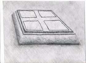
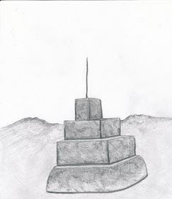
II.3) Cubic mountaintop tombs
Another characteristic class of archaic monuments in Upper Tibet is cubic stone tombs. In this survey, 22 such sites are presented. The above-ground cubic tombs were erected on the tops of high ridges and mountains to an elevation of 5600 m. The cubic tombs were almost always sited on summits thickly blanketed in talus. They were frequently set on the edge of high points overlooking steep slopes or cliffs with panoramic views of the adjoining countryside. These sites often comprise the highest ground around for some distance. The cubic tombs were generally built of locally occurring dark-colored sandstone and volcanic slabs and chunks (up to 1.2 m in length), laid flat in random-texture, dry-mortar courses. The exterior dimensions of the tombs range between 1.5 m by 1.5 m by 1.2 m and 2.5 m by 3.5 m by 1.8 m. The walls are usually aligned in the cardinal directions, an important feature of many pillar and enclosure sites as well. The top of the tombs are flat, and virtually all have been opened and the contents discarded or stolen.
There is a rectangular chamber set in the center of the masonry carapace elevated around 50 cm above ground level. Measuring in the range of 80 cm by 50 cm to 2 m by 1.1 m, finer sized stones were used to fashion these central chambers. The chambers are also normally aligned in the compass points. These 70 cm to 1.1 m deep openings appear to have functioned as reliquaries. Their association in the oral tradition with the ancient Mön and the occasional adventitious usage of the chambers to accommodate human burial bear this out. It would appear that skeletal elements, the products of fractional or secondary burials, were deposited in the central chambers. Given their size, extended corpse burials would not have been feasible (unless they were used for juvenile inhumations) except in the largest central chambers, a small minority of the total. Tibetan historic era reliquary structures are mud plastered and colorfully painted, and it does not seem likely that the cubic tombs were originally fabricated as raw unadorned stone chests.
Curiously, the geographic distribution of the cubic tombs is restricted to western Tibet. They occur both north and south of the Transhimalaya (Gangkar Tisé) range, between 84° 33΄ and 79° 03΄ E. Longitude. The cultural factors explaining why the cubic mountaintop tombs are confined to this specific region are still obscure. Other characteristic monuments of Upper Tibet, such as the all-stone edifices, pillars erected inside quadrate enclosures, and arrays of pillars appended to edifices, enjoy much wider territorial dispersal
A Bön scriptural account seems to describe a form of burial for ancient priests known as shen, which may correspond to the form and lofty aspect of the cubic mountaintop tombs.1 If indeed this textual source is related to the tombs under consideration, it indicates that they were used to dispose of the mortal remains of high status priests in prehistoric times. Clearly, the siting of tombs in high, inaccessible locales intimates an exclusive social sphere of usage. This aura of special status is supported by the relatively small number of such cemeteries thus far documented.
I have presented ethnographic data to suggest that the lofty aspect of the sites was connected to a belief in a celestial afterlife.2 This is also supported by Tibetan funerary texts that describe a celestial afterlife known as gayül (Joyous Country), a paradise paralleling in ideal terms the mortal way of life.3 It would seem that the mountaintop tombs served as a kind of launch pad for the deceased on its journey to the hereafter. Some mountaintop sites (see E-11, E-19, E-30) with their terraces, pads, pathways and walls, all constructed from talus, indicates that there was indeed a complex ceremonial component attached to the burials.
Special attention has been paid to identifying and collecting osteological samples from the ruins of the central depositories. Only a small fraction of the total number of tombs contain skeletal remains and these are all tiny, hard to distinguish fragments. The samples collected were partially or fully exposed to the elements and subject to infiltration by foreign organic substances. Samples taken from tombs of the Endritsé (E-11) (fragment of cranium, human?) and Denjangri Mukpo Dong (E-18) (human cuspid and jaw fragment, other bone matter) cemeteries have yielded dates so recent as to fall outside the range of radiocarbon calibration. One sample of bone (species undetermined), collected from the central depository of a cubic tomb near Denjangri Mukpo Dong, has yielded a calibrated radiocarbon date of circa 1000 to 1210 CE. It is not at all clear, however, if the sample dated represents part of an original interment or a subsequent addition to the tomb. More stringent sampling will be required in order to determine the age of the cubic tombs.
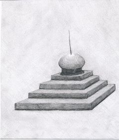
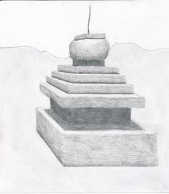
II.4) Shrines and miscellaneous constructions
|
|
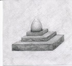
At a number of residential sites in Upper Tibet , there are the ruins of shrines that can be assigned to the archaic assemblage of monuments. These structures are found both outdoors and in caves used for habitation. Most of them appear to belong to the tenkhar, sekhar, lhaten, or lhatsuk classes of monuments, cubic or stepped tabernacles used to enshrine and propitiate indigenous deities. While forms of these monuments are still constructed today, according to Bön tradition, their origins can be traced to prehistoric times. Fairly well-preserved examples sheltered in caves are sometimes covered in a mud veneer and decorated with red and yellow ochre and lime pigments. The shrines have square or rectangular bases and were built of stone slabs and blocks. Some specimens may have had elaborate superstructures, as indicated by the depiction of archaic shrines in the rock art of Upper Tibet, but few traces remain. Archaic shrines can be distinguished from the ruined bases of chöten by the absence of overhanging masonry tiers, coursed-rubble stonework, etc. Also, unlike chöten, some archaic shrines were partly built underground. It is probable that a wide range of ritual functions and chronologies is indicated for this heterogeneous class of ceremonial monuments.
Only two sites surveyed to date are composed exclusively of shrines. Pangar Zhungkhang Gok (F-1) consists of six large cubic structures, situated on the edge of an extensive pastureland.1 It is possible that the limestone structures of Pangar Zhungkhang Gok represent an unknown type of above-ground tomb, as their construction is locally attributed to the ancient Mön. The celebrated monument known as Guru Bumpa (F-2), located in Purang, is maintained to the present day (it was partly destroyed in the Chinese Cultural Revolution). It consists of two large unmortared stepped structures chiefly built of cobbles tinted red with ochre. According to the local myth, the 8th century CE Vajrayāna hero Guru Rinpoché magically built these twin shrines in the amount of time it took for his disciple to prepare a pot of rice. Stepped shrines of the same form are a significant motif in Upper Tibetan petroglyphs and pictographs, all of which appear to predate the 13th century CE.2
|
|
III. Agricultural Structures
In the vicinity of some residential sites there are the remains of agricultural terracing and irrigation channels. Walls bounding long abandoned arable parcels (zhingsa) are common in western Tibet (including sites A-13, A-42, A-60, A-62, A-87, A-89, A-101, A-106, A-125, A-126, B-50, B-79, B-81, etc.). These former agricultural enclaves are commonly attributed to the ancient Mön, who are supposed to have cultivated large areas of what is now only pasturage. At many erstwhile agrarian sites in western Tibet, all perennial sources of water have dried up. Defunct agricultural holdings are also evident on the shores of Dangra Yutso, in the central Jangtang (including sites B-4, B-6, B-55, B-57, B-58, B-59, etc.). Some of these Lake Dangra sites are attributed, in the local oral tradition, to the prehistoric Zhang Zhung kingdom. The Lungön site (G-3) is especially noteworthy because the water it carried from deep inside the Lungön Valley flowed to Dangra Khyungdzong (A-5) a fabled capital of Zhang Zhung.
In the face of appreciable geographical evidence, the legends circulating in Upper Tibet (west of the 87th meridian) that tell of much more widely practiced agriculture in ancient times, are undoubtedly based on an authentic collective memory. Rutok, Gugé, and Gar, in particular, were very much more heavily farmed in the past. These former arable lands are frequently encountered in proximity to ruined villages and citadels, many of which now lie totally deserted. One implication of larger locally produced grain reserves is that they may have been used to sustain larger populations. The oral traditions of Rutok claim so much, stating that this district in ancient times supported upwards of 100,000 people, ten times the current population.1 While such legends are hyperbolic, they do seem to preserve an authentic memory of a more developed past in parts of Upper Tibet.
IV. Earthworks
This division of monuments is geographically confined to the south side of the Nyenchen Tanglha massif, in the Nyingdrung and Damzhung localities. Four sites, consisting of broad earthen walls, 2 m to 3 m in height and of similar width, have been surveyed. These walls form quadrate structures up to 250 m in length. Within these walls there is highly disturbed ground covered in pits and small mounds. Earthen platforms are found near some of the walled structures. There is great scope for further exploration of these enigmatic structures.